
Introduction
AI HD Map Change Detection tools use artificial intelligence, computer vision, geospatial data processing, and machine learning techniques to identify changes in high-definition maps used by autonomous vehicles, smart transportation systems, and location-based applications. These tools analyze large amounts of road data collected from sensors, satellite imagery, LiDAR, cameras, and vehicle fleets to detect updates such as new roads, lane changes, construction areas, traffic infrastructure modifications, and environmental changes.
HD maps are becoming increasingly important as vehicles rely on accurate environmental information for navigation, positioning, and advanced driver assistance capabilities. Traditional manual map updates are slow and expensive, making AI-powered change detection essential for maintaining accurate and continuously updated road information.
Modern AI HD Map Change Detection systems combine multimodal data processing, automated feature extraction, machine learning models, and validation workflows. They help organizations improve map freshness, reduce operational costs, and support safer mobility experiences.
Real-world use cases:
- Autonomous vehicle companies use AI map change detection to maintain accurate road information for navigation systems.
- Automotive manufacturers use updated HD maps to improve advanced driver assistance capabilities.
- Mapping companies use AI to detect road changes from vehicle sensor data and satellite imagery.
- Transportation agencies use AI analysis to monitor infrastructure changes and road conditions.
- Logistics companies use updated maps to improve route planning and fleet efficiency.
- Smart city programs use AI mapping tools to maintain digital representations of urban environments.
Evaluation Criteria for Choosing AI HD Map Change Detection Tools
Organizations should evaluate AI HD Map Change Detection platforms based on:
- Accuracy of detecting road and infrastructure changes.
- Support for LiDAR, camera, satellite, and sensor data.
- AI model performance for geospatial analysis.
- Real-time or near-real-time update capabilities.
- Data processing scalability.
- Cloud, edge, and hybrid deployment options.
- Integration with mapping platforms and automotive systems.
- Machine learning evaluation workflows.
- Data privacy and security controls.
- API and developer support.
- Quality assurance and validation processes.
- Cost efficiency for large-scale mapping operations.
Best for:
Automotive manufacturers, autonomous driving companies, mapping providers, transportation organizations, logistics companies, and smart city teams that require continuously updated geographic information and accurate road intelligence.
Not ideal for:
Small organizations without mapping requirements, businesses that only need basic navigation solutions, or teams without access to geospatial data and AI development resources.
What’s Changed in AI HD Map Change Detection
AI HD Map Change Detection is evolving rapidly as transportation systems demand faster, more accurate, and automated mapping updates.
- AI-powered map automation: Organizations are moving away from manual map updates toward automated systems capable of detecting changes from large-scale sensor datasets.
- Multimodal geospatial intelligence: Modern systems combine LiDAR, camera imagery, satellite data, GPS information, and vehicle telemetry for better environmental understanding.
- Real-time map updates: AI platforms are improving their ability to identify and process road changes faster for connected and autonomous vehicles.
- Foundation models for geospatial AI: Large AI models are being explored for understanding complex geographic patterns and environmental changes.
- Crowdsourced mapping intelligence: Vehicle fleets and connected devices are becoming valuable sources of continuous map improvement.
- Edge AI processing: Some mapping workflows are moving closer to vehicles and sensors to reduce latency and improve data efficiency.
- Automated quality validation: AI systems increasingly help identify inaccurate map elements, duplicate information, and outdated road features.
- Simulation-based testing: Autonomous vehicle developers use simulated environments to test how map changes affect navigation and perception systems.
- Privacy-aware mapping workflows: Organizations are focusing more on secure handling of location data, vehicle information, and visual sensor data.
- Cloud-scale geospatial processing: Large mapping operations increasingly rely on scalable AI infrastructure for processing massive datasets.
Quick Buyer Checklist
Use this checklist before selecting an AI HD Map Change Detection platform:
- ✅ Does the platform support multiple data sources such as LiDAR, imagery, and GPS?
- ✅ Can it automatically detect road and infrastructure changes?
- ✅ Does it support large-scale geospatial data processing?
- ✅ Can it integrate with existing mapping platforms?
- ✅ Does it provide AI model evaluation capabilities?
- ✅ Are data privacy and retention controls available?
- ✅ Can the platform operate in cloud, edge, or hybrid environments?
- ✅ Does it support automated validation workflows?
- ✅ Are APIs and SDKs available for developers?
- ✅ Can it handle frequent map updates?
- ✅ Does it support autonomous driving workflows?
- ✅ Does it reduce dependence on manual mapping processes?
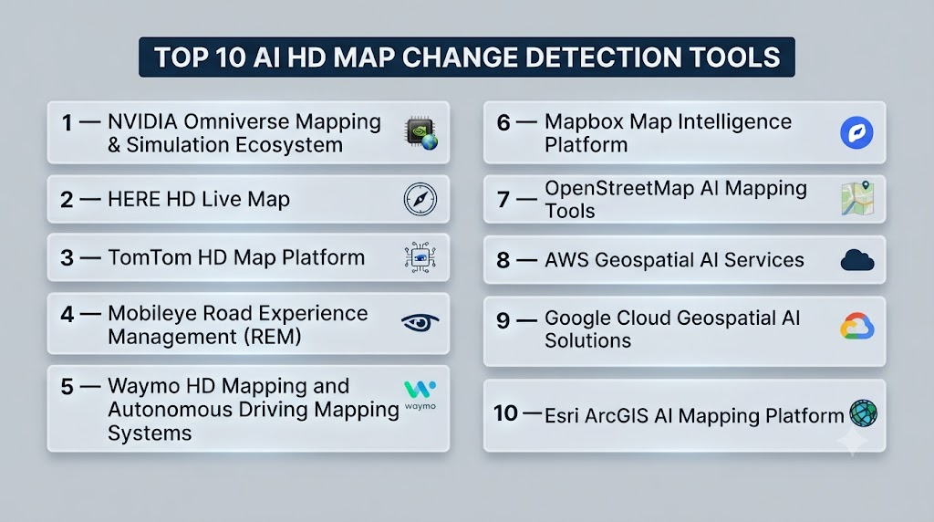
Top 10 AI HD Map Change Detection Tools
#1 — NVIDIA Omniverse Mapping & Simulation Ecosystem
One-line verdict: Best for automotive teams building AI-driven simulation and digital twin mapping workflows.
Short description:
NVIDIA Omniverse provides technologies for creating digital environments, simulations, and AI development workflows. It supports organizations working on autonomous systems, virtual testing, and advanced mapping scenarios.
Standout Capabilities
- Digital twin creation.
- AI simulation workflows.
- Synthetic data generation.
- 3D environment development.
- Autonomous vehicle testing support.
- Realistic simulation environments.
- Geospatial visualization workflows.
- AI development integration.
AI-Specific Depth
- Model support: Supports AI development workflows using compatible models.
- RAG / knowledge integration: N/A.
- Evaluation: Supports simulation-based testing; detailed evaluation methods vary.
- Guardrails: Safety implementation depends on application design.
- Observability: Depends on deployed workflows.
Pros
- Strong simulation capabilities.
- Useful for autonomous vehicle development.
- Supports complex 3D environments.
Cons
- Requires specialized technical expertise.
- Not a dedicated HD map update platform.
- Hardware requirements may vary.
Security & Compliance
Security features depend on deployment architecture. Specific certifications are not publicly stated.
Deployment & Platforms
- Cloud environments.
- Workstations.
- Simulation infrastructure.
- AI development environments.
Integrations & Ecosystem
Supports:
- 3D content workflows.
- AI development tools.
- Simulation platforms.
- Automotive engineering systems.
- Digital twin applications.
Pricing Model
Not publicly stated. Enterprise licensing varies depending on deployment requirements.
Best-Fit Scenarios
- Autonomous vehicle simulation.
- Automotive research teams.
- Digital twin development.
#2 — HERE HD Live Map
One-line verdict: Best for automotive companies requiring high-definition mapping and location intelligence.
Short description:
HERE HD Live Map provides high-definition mapping capabilities designed for automotive and mobility applications. It supports accurate road information used by advanced navigation and driver assistance systems.
Standout Capabilities
- High-definition road mapping.
- Lane-level information.
- Road attribute management.
- Location intelligence.
- Automotive navigation support.
- Map data processing.
- Mobility ecosystem integration.
AI-Specific Depth
- Model support: Proprietary mapping technologies; details vary.
- RAG / knowledge integration: N/A.
- Evaluation: Mapping quality validation processes are used; specific AI evaluation methods are not publicly stated.
- Guardrails: Data quality and safety processes vary.
- Observability: Mapping analytics capabilities depend on implementation.
Pros
- Strong expertise in digital mapping.
- Designed for automotive applications.
- Supports location-based services.
Cons
- Enterprise-focused solution.
- Integration requires mapping expertise.
- Pricing details are not publicly stated.
Security & Compliance
Specific certifications and compliance details are not publicly stated.
Deployment & Platforms
- Cloud-based mapping services.
- Automotive integration environments.
Integrations & Ecosystem
Supports:
- Automotive systems.
- Navigation platforms.
- Mobility applications.
- Location intelligence workflows.
Pricing Model
Not publicly stated.
Best-Fit Scenarios
- Automotive navigation systems.
- Connected vehicle programs.
- Mobility service providers.
#3 — TomTom HD Map Platform
One-line verdict: Best for organizations needing automotive-grade mapping data and road intelligence.
Short description:
TomTom HD Map technologies support advanced navigation and autonomous mobility applications. The platform focuses on delivering detailed road information for intelligent transportation systems.
Standout Capabilities
- HD road mapping.
- Lane-level navigation data.
- Location intelligence.
- Automotive map services.
- Road attribute information.
- Mobility data processing.
- Map content management.
AI-Specific Depth
- Model support: Proprietary mapping technologies.
- RAG / knowledge integration: N/A.
- Evaluation: Map validation processes exist; detailed AI evaluation methods are not publicly stated.
- Guardrails: Data quality controls vary.
- Observability: Monitoring depends on implementation.
Pros
- Established mapping expertise.
- Strong automotive focus.
- Useful for connected mobility solutions.
Cons
- Primarily designed for enterprise users.
- Custom AI development may require additional tools.
- Pricing information is not publicly stated.
Security & Compliance
Specific security certifications are not publicly stated.
Deployment & Platforms
- Cloud mapping services.
- Automotive platforms.
Integrations & Ecosystem
Supports:
- Navigation systems.
- Automotive software.
- Mobility applications.
- Location-based services.
Pricing Model
Not publicly stated.
Best-Fit Scenarios
- Automotive manufacturers.
- Navigation providers.
- Transportation technology companies.
#4 — Mobileye Road Experience Management (REM)
One-line verdict: Best for automotive organizations using vehicle data to improve HD map freshness and road intelligence.
Short description:
Mobileye Road Experience Management uses data collected from vehicles to support map creation and updating workflows. It combines computer vision, crowdsourced vehicle information, and AI processing to improve road environment understanding.
Standout Capabilities
- Crowdsourced road data collection.
- AI-based road feature extraction.
- Map update workflows.
- Vehicle-generated mapping insights.
- Road environment analysis.
- Scalable automotive data processing.
- ADAS and autonomous driving support.
- Lane-level road information.
AI-Specific Depth
- Model support: Proprietary AI perception models.
- RAG / knowledge integration: N/A.
- Evaluation: Uses automotive validation processes; detailed AI evaluation methods are not publicly stated.
- Guardrails: Safety-focused automotive development practices; specific AI guardrails are not publicly stated.
- Observability: Data monitoring capabilities vary by deployment.
Pros
- Uses real-world vehicle data for map improvement.
- Strong automotive ecosystem.
- Supports large-scale road intelligence workflows.
Cons
- Primarily designed for automotive partners.
- Limited direct developer access.
- Deployment requires vehicle data integration.
Security & Compliance
Security controls and certifications vary by implementation. Specific certifications are not publicly stated.
Deployment & Platforms
- Vehicle-integrated systems.
- Cloud-based processing environments.
- Automotive data platforms.
Integrations & Ecosystem
Supports:
- Vehicle sensor systems.
- Automotive software platforms.
- ADAS workflows.
- Mapping applications.
- Mobility services.
Pricing Model
Not publicly stated.
Best-Fit Scenarios
- Automotive manufacturers.
- Autonomous vehicle developers.
- Large mobility companies.
#5 — Waymo HD Mapping and Autonomous Driving Mapping Systems
One-line verdict: Best for autonomous mobility organizations requiring highly detailed road environment understanding.
Short description:
Waymo develops advanced mapping systems as part of its autonomous driving technology stack. Its mapping workflows combine sensor data, machine learning, and simulation environments to maintain detailed road representations.
Standout Capabilities
- High-definition road modeling.
- Autonomous driving map creation.
- Sensor-based data processing.
- Road feature detection.
- Simulation environment support.
- Vehicle data integration.
- Localization support.
- Advanced mobility workflows.
AI-Specific Depth
- Model support: Proprietary AI models.
- RAG / knowledge integration: N/A.
- Evaluation: Uses internal testing and validation workflows; details are not publicly stated.
- Guardrails: Safety-focused autonomous system processes.
- Observability: Internal monitoring details are not publicly stated.
Pros
- Advanced autonomous driving expertise.
- Strong focus on safety-critical mapping.
- Uses large-scale real-world data.
Cons
- Not available as a general-purpose commercial tool.
- Internal technologies are limited externally.
- Designed for large autonomous mobility programs.
Security & Compliance
Specific certifications and security details are not publicly stated.
Deployment & Platforms
- Autonomous vehicle platforms.
- Simulation environments.
- Cloud processing infrastructure.
Integrations & Ecosystem
Supports:
- Autonomous driving systems.
- Sensor platforms.
- Simulation workflows.
- Vehicle intelligence platforms.
Pricing Model
Not publicly stated.
Best-Fit Scenarios
- Autonomous vehicle research.
- Mobility technology programs.
- Advanced transportation development.
#6 — Mapbox Map Intelligence Platform
One-line verdict: Best for developers building location-aware applications with customizable mapping workflows.
Short description:
Mapbox provides mapping technologies and location intelligence tools that help developers create interactive maps and location-based applications. It can support workflows involving geospatial data analysis and map updates.
Standout Capabilities
- Custom mapping experiences.
- Geospatial visualization.
- Location data processing.
- Navigation support.
- Developer APIs.
- Map customization.
- Real-time location services.
- Data visualization tools.
AI-Specific Depth
- Model support: AI capabilities vary by implementation.
- RAG / knowledge integration: N/A.
- Evaluation: Depends on application workflows.
- Guardrails: Application-specific.
- Observability: Platform monitoring depends on implementation.
Pros
- Developer-friendly ecosystem.
- Flexible mapping customization.
- Strong location-based application support.
Cons
- Not specifically focused only on HD map change detection.
- Advanced automotive use cases may require additional solutions.
- AI capabilities vary.
Security & Compliance
Security controls depend on deployment and usage configuration.
Deployment & Platforms
- Cloud-based platform.
- Web applications.
- Mobile applications.
Integrations & Ecosystem
Supports:
- APIs.
- SDKs.
- Mobile applications.
- Web platforms.
- Location-based services.
Pricing Model
Usage-based pricing model. Exact costs vary depending on usage.
Best-Fit Scenarios
- Location application developers.
- Mobility startups.
- Geospatial technology projects.
#7 — OpenStreetMap AI Mapping Tools
One-line verdict: Best for open mapping communities and organizations building customized geospatial solutions.
Short description:
OpenStreetMap-based AI mapping workflows use open geographic data combined with machine learning tools to identify and update map information. These solutions are often used for research, humanitarian projects, and custom mapping applications.
Standout Capabilities
- Open geographic datasets.
- Community-driven map updates.
- AI-assisted feature detection.
- Geospatial analysis.
- Custom mapping workflows.
- Research flexibility.
- Data accessibility.
AI-Specific Depth
- Model support: Depends on selected AI tools and frameworks.
- RAG / knowledge integration: N/A.
- Evaluation: Requires custom validation workflows.
- Guardrails: Depends on implementation.
- Observability: Requires additional tooling.
Pros
- Open data accessibility.
- High customization potential.
- Useful for research and experimentation.
Cons
- Requires technical expertise.
- Data quality may vary by region.
- Production automotive use requires additional validation.
Security & Compliance
Depends on implementation.
Deployment & Platforms
- Cloud.
- Local development environments.
- GIS platforms.
Integrations & Ecosystem
Supports:
- GIS tools.
- AI frameworks.
- Data analysis platforms.
- Mapping applications.
Pricing Model
Open data ecosystem. Additional infrastructure costs vary.
Best-Fit Scenarios
- Research organizations.
- Developers.
- Custom mapping projects.
#8 — AWS Geospatial AI Services
One-line verdict: Best for enterprises building scalable cloud-based geospatial AI workflows.
Short description:
AWS provides cloud infrastructure and geospatial capabilities that organizations can use to build AI-powered mapping and location intelligence applications. Teams can combine machine learning services with geographic data processing.
Standout Capabilities
- Cloud-scale geospatial processing.
- Machine learning integration.
- Data analytics workflows.
- Scalable infrastructure.
- Location intelligence applications.
- Data storage capabilities.
- AI model deployment support.
AI-Specific Depth
- Model support: Supports custom machine learning workflows.
- RAG / knowledge integration: N/A.
- Evaluation: Organizations build custom evaluation pipelines.
- Guardrails: Cloud security controls available; AI guardrail implementation depends on usage.
- Observability: Cloud monitoring capabilities available.
Pros
- Enterprise scalability.
- Strong cloud infrastructure.
- Flexible AI development options.
Cons
- Requires cloud expertise.
- Not a ready-made HD map change detection product.
- Implementation requires engineering resources.
Security & Compliance
Cloud security features depend on configuration. Specific certifications vary by service usage.
Deployment & Platforms
- Cloud environments.
- Hybrid architectures.
- Enterprise infrastructure.
Integrations & Ecosystem
Supports:
- Cloud services.
- Machine learning platforms.
- Data pipelines.
- Geospatial applications.
- Enterprise systems.
Pricing Model
Usage-based cloud pricing. Exact costs vary by resources consumed.
Best-Fit Scenarios
- Enterprise mapping projects.
- Large-scale data processing.
- Cloud-based AI development.
#9 — Google Cloud Geospatial AI Solutions
One-line verdict: Best for organizations combining cloud AI with large-scale geographic data analysis.
Short description:
Google Cloud provides geospatial data and AI capabilities that help organizations analyze location information, imagery, and geographic datasets. These services can support map intelligence and change analysis workflows.
Standout Capabilities
- Large-scale geospatial analysis.
- AI model integration.
- Satellite and geographic data processing.
- Cloud-based analytics.
- Data visualization.
- Machine learning workflows.
- Location intelligence.
AI-Specific Depth
- Model support: Supports custom AI and machine learning workflows.
- RAG / knowledge integration: N/A.
- Evaluation: Depends on customer-developed models.
- Guardrails: Cloud security and AI governance features vary.
- Observability: Cloud monitoring tools available.
Pros
- Strong cloud AI ecosystem.
- Handles large datasets.
- Suitable for advanced analytics.
Cons
- Requires cloud expertise.
- Not designed specifically as a complete HD map platform.
- Costs depend on usage.
Security & Compliance
Security capabilities depend on configuration and services selected.
Deployment & Platforms
- Cloud-based.
- Enterprise data environments.
Integrations & Ecosystem
Supports:
- Cloud AI services.
- Data analytics platforms.
- Geographic datasets.
- Machine learning systems.
Pricing Model
Usage-based cloud pricing.
Best-Fit Scenarios
- Enterprise geospatial analytics.
- Smart city projects.
- Large mapping workflows.
#10 — Esri ArcGIS AI Mapping Platform
One-line verdict: Best for organizations requiring enterprise GIS analysis with AI-powered mapping workflows.
Short description:
Esri ArcGIS provides geographic information system capabilities used for mapping, spatial analysis, and location intelligence. Organizations can combine AI techniques with GIS workflows to analyze geographic changes.
Standout Capabilities
- Enterprise GIS management.
- Spatial analysis.
- Mapping workflows.
- Geographic data visualization.
- AI-assisted analysis.
- Data management.
- Location intelligence.
AI-Specific Depth
- Model support: Supports integration with AI and machine learning workflows.
- RAG / knowledge integration: N/A.
- Evaluation: Depends on implemented models.
- Guardrails: Enterprise governance capabilities vary.
- Observability: Depends on deployment.
Pros
- Strong enterprise GIS capabilities.
- Wide geospatial ecosystem.
- Suitable for large organizations.
Cons
- Requires GIS expertise.
- Automotive HD mapping requires customization.
- Licensing details vary.
Security & Compliance
Security features depend on deployment environment and configuration.
Deployment & Platforms
- Cloud.
- Desktop.
- Enterprise GIS environments.
Integrations & Ecosystem
Supports:
- GIS databases.
- AI platforms.
- Data visualization tools.
- Enterprise systems.
- Geospatial applications.
Pricing Model
Not publicly stated. Enterprise GIS licensing varies.
Best-Fit Scenarios
- Government mapping projects.
- Smart cities.
- Enterprise geospatial analysis.
Part 3 will include:
- AI HD Map Change Detection Comparison Table
- Scoring & Evaluation Rubric
- Enterprise / SMB / Developer Recommendations
- Decision Guide
- 30/60/90 Implementation Playbook
- Common Mistakes
- FAQs
- Conclusion
- 5 SEO hashtags
Comparison Table: Top 10 AI HD Map Change Detection Tools
| Tool Name | Best For | Deployment | Model Flexibility | Strength | Watch-Out | Public Rating |
|---|---|---|---|---|---|---|
| NVIDIA Omniverse Mapping & Simulation Ecosystem | Autonomous vehicle simulation teams | Cloud / Workstation / Hybrid | AI ecosystem-based | Digital twin and simulation workflows | Not a dedicated map update platform | N/A |
| HERE HD Live Map | Automotive mapping organizations | Cloud | Proprietary mapping technology | Automotive-grade HD mapping | Enterprise integration complexity | N/A |
| TomTom HD Map Platform | Connected vehicle programs | Cloud | Proprietary mapping solutions | Road intelligence and navigation data | Limited customization | N/A |
| Mobileye Road Experience Management | Automotive manufacturers | Vehicle + Cloud | Proprietary AI models | Crowdsourced road intelligence | Requires vehicle data integration | N/A |
| Waymo Mapping Systems | Autonomous driving programs | Vehicle + Simulation | Proprietary AI models | Advanced autonomous mapping | Not publicly available as a tool | N/A |
| Mapbox Map Intelligence Platform | Developers and mobility applications | Cloud | Flexible development ecosystem | Custom mapping applications | Not specifically HD map focused | N/A |
| OpenStreetMap AI Mapping Tools | Researchers and developers | Cloud / Local | Open ecosystem | Flexible open mapping workflows | Requires validation | N/A |
| AWS Geospatial AI Services | Enterprise cloud teams | Cloud / Hybrid | Custom AI models | Scalable geospatial processing | Requires engineering expertise | N/A |
| Google Cloud Geospatial AI Solutions | Data-driven mapping organizations | Cloud | Custom AI workflows | Large-scale geographic analysis | Cloud expertise required | N/A |
| Esri ArcGIS AI Mapping Platform | Enterprise GIS organizations | Cloud / Desktop / Enterprise | AI integration support | Enterprise GIS capabilities | Requires GIS knowledge | N/A |
Scoring & Evaluation: Transparent Rubric
The following evaluation compares AI HD Map Change Detection tools using practical criteria for automotive, geospatial, and enterprise applications. Scores are comparative indicators and may vary depending on deployment requirements, data availability, business objectives, and technical resources.
The scoring focuses on map intelligence capabilities, AI reliability, integration ecosystem, deployment flexibility, security controls, performance optimization, and operational usability.
| Tool | Core Features | Reliability/Eval | Guardrails | Integrations | Ease | Perf/Cost | Security/Admin | Support | Weighted Total |
|---|---|---|---|---|---|---|---|---|---|
| NVIDIA Omniverse Mapping Ecosystem | 9 | 9 | 8 | 9 | 7 | 9 | 8 | 9 | 8.65 |
| HERE HD Live Map | 10 | 9 | 9 | 9 | 8 | 8 | 9 | 9 | 9.00 |
| TomTom HD Map Platform | 9 | 9 | 8 | 9 | 8 | 8 | 9 | 9 | 8.75 |
| Mobileye Road Experience Management | 10 | 9 | 9 | 8 | 7 | 9 | 9 | 8 | 8.90 |
| Waymo Mapping Systems | 10 | 10 | 9 | 8 | 6 | 9 | 9 | 8 | 8.85 |
| Mapbox Map Intelligence Platform | 8 | 8 | 7 | 10 | 9 | 8 | 8 | 9 | 8.45 |
| OpenStreetMap AI Mapping Tools | 8 | 7 | 7 | 10 | 8 | 8 | 7 | 10 | 8.00 |
| AWS Geospatial AI Services | 8 | 9 | 8 | 10 | 8 | 9 | 10 | 9 | 8.95 |
| Google Cloud Geospatial AI Solutions | 9 | 9 | 8 | 10 | 8 | 9 | 10 | 9 | 9.00 |
| Esri ArcGIS AI Mapping Platform | 9 | 9 | 8 | 10 | 8 | 8 | 9 | 10 | 8.95 |
Top 3 for Enterprise
1. HERE HD Live Map
Best suited for automotive organizations requiring mature HD mapping capabilities and road intelligence.
2. Google Cloud Geospatial AI Solutions
Strong choice for enterprises processing large-scale geographic data with AI workflows.
3. AWS Geospatial AI Services
Suitable for organizations requiring flexible cloud infrastructure for mapping intelligence projects.
Top 3 for SMB
1. Mapbox Map Intelligence Platform
Useful for companies building location-based applications with customizable mapping requirements.
2. OpenStreetMap AI Mapping Tools
Good option for organizations needing flexible and cost-conscious mapping workflows.
3. AWS Geospatial AI Services
Suitable for growing companies that need scalable cloud-based geospatial processing.
Top 3 for Developers
1. OpenStreetMap AI Mapping Tools
Provides flexibility for developers creating custom mapping solutions.
2. Mapbox Map Intelligence Platform
Offers strong APIs and developer-focused mapping capabilities.
3. NVIDIA Omniverse Mapping & Simulation Ecosystem
Useful for developers working on simulation and autonomous vehicle environments.
Which AI HD Map Change Detection Tool Is Right for You?
The right AI HD Map Change Detection solution depends on your industry, data requirements, technical capabilities, and operational goals. Different organizations need different approaches.
A company building autonomous vehicles may require automotive-grade HD maps, while a developer building location applications may prefer flexible APIs and cloud services.
Solo / Freelancer
Individual developers and researchers typically need flexible tools for experimentation and application development.
Recommended options:
- OpenStreetMap AI Mapping Tools.
- Mapbox Map Intelligence Platform.
- Open-source geospatial AI frameworks.
Focus areas:
- API availability.
- Documentation quality.
- Data accessibility.
- Development flexibility.
- Low infrastructure requirements.
SMB
Small and medium businesses often need practical mapping capabilities without large infrastructure investments.
Recommended options:
- Mapbox Map Intelligence Platform.
- AWS Geospatial AI Services.
- OpenStreetMap-based workflows.
Focus areas:
- Cost efficiency.
- Easy integration.
- Scalable infrastructure.
- Developer support.
Mid-Market
Growing organizations working on mobility, logistics, or location intelligence need scalable platforms.
Recommended options:
- AWS Geospatial AI Services.
- Google Cloud Geospatial AI Solutions.
- Esri ArcGIS AI Mapping Platform.
Focus areas:
- Data processing capability.
- Workflow automation.
- Integration with business systems.
- Operational analytics.
Enterprise
Large automotive and transportation organizations require reliable, scalable, and secure mapping solutions.
Recommended options:
- HERE HD Live Map.
- TomTom HD Map Platform.
- Mobileye Road Experience Management.
Focus areas:
- Automotive integration.
- Map accuracy.
- Large-scale deployment.
- Data governance.
- Long-term support.
Regulated Industries
Organizations working with public infrastructure, transportation systems, or sensitive location data should prioritize:
- Strong data governance.
- Secure processing.
- Access controls.
- Audit capabilities.
- Privacy protection.
Recommended approach:
- Review data collection practices.
- Validate security controls.
- Establish clear ownership of mapping data.
- Maintain human validation for critical updates.
Budget vs Premium
Budget-focused approach
Prioritize:
- Open-source tools.
- Cloud-based APIs.
- Flexible development frameworks.
- Limited infrastructure requirements.
Suitable options:
- OpenStreetMap AI workflows.
- Mapbox.
- Cloud geospatial services.
Premium approach
Prioritize:
- Automotive-grade accuracy.
- Continuous updates.
- Advanced sensor processing.
- Enterprise support.
Suitable options:
- HERE HD Live Map.
- TomTom HD Map Platform.
- Mobileye REM.
Build vs Buy: When to DIY
Build internally when:
- You have strong AI and geospatial engineering teams.
- You need complete control over mapping models.
- Your organization has unique data sources.
- Custom workflows are required.
Buy a platform when:
- You need faster deployment.
- Accuracy requirements are high.
- You lack specialized mapping expertise.
- You need ongoing vendor support.
A hybrid approach is often effective. Organizations can combine commercial HD mapping data with custom AI models to create specialized solutions.
Implementation Playbook: 30 / 60 / 90 Days
First 30 Days: Pilot and Define Success Metrics
Main objectives:
- Identify mapping requirements.
- Select test regions or datasets.
- Establish evaluation criteria.
Key activities:
- Collect available geographic data.
- Compare existing maps with updated information.
- Test AI change detection accuracy.
- Identify important road features.
AI-specific tasks:
- Create evaluation datasets.
- Define accuracy benchmarks.
- Test different sensor inputs.
- Document detection errors.
First 60 Days: Security, Validation, and Integration
Main objectives:
- Improve reliability.
- Connect operational systems.
- Prepare production workflows.
Key activities:
- Integrate mapping APIs.
- Validate detected changes.
- Configure access controls.
- Review data management practices.
AI-specific tasks:
- Build model evaluation pipelines.
- Test unusual road scenarios.
- Review false positives and missed changes.
- Establish model version tracking.
First 90 Days: Scale and Governance
Main objectives:
- Expand coverage.
- Optimize performance.
- Create governance processes.
Key activities:
- Increase geographic coverage.
- Automate update workflows.
- Improve processing efficiency.
- Monitor system performance.
AI-specific tasks:
- Monitor model drift.
- Update training datasets.
- Improve validation workflows.
- Establish AI incident handling procedures.
- Maintain governance documentation.
Common Mistakes & How to Avoid Them
- Choosing a platform without evaluating data quality.
- Ignoring geographic coverage limitations.
- Using outdated mapping datasets.
- Deploying AI models without validation.
- Failing to test rare road scenarios.
- Ignoring privacy concerns around vehicle data.
- Underestimating storage requirements.
- Not planning API integration early.
- Overlooking sensor compatibility.
- Focusing only on AI accuracy without operational needs.
- Lack of human validation for important map updates.
- Poor version management of map datasets.
- Ignoring security risks in location data.
- Selecting tools without considering future scalability.
FAQs
What is AI HD Map Change Detection?
AI HD Map Change Detection uses artificial intelligence to identify differences between existing maps and newly collected geographic data.
Why are HD maps important for autonomous vehicles?
HD maps provide detailed road information that helps vehicles understand lanes, road structures, and driving environments.
What data sources are used for HD map updates?
Common sources include LiDAR, cameras, satellite imagery, GPS data, and vehicle sensor information.
Can AI automatically update HD maps?
AI can automate many change detection tasks, but human validation may still be required for safety-critical updates.
Are AI HD mapping tools expensive?
Costs vary depending on data volume, infrastructure, licensing, and deployment requirements.
Can small companies use AI mapping tools?
Yes. Smaller companies can use cloud platforms, APIs, and open-source solutions depending on their needs.
Do these tools support real-time updates?
Some platforms support frequent updates, while others rely on scheduled processing workflows.
Can organizations build their own HD map systems?
Yes, organizations with AI and geospatial expertise can create custom mapping workflows.
How accurate are AI map change detection systems?
Accuracy depends on data quality, AI models, sensor inputs, and validation processes.
Are HD maps only used for autonomous vehicles?
No. They are also used in logistics, smart cities, navigation systems, and transportation planning.
What security concerns exist with HD mapping?
Organizations should protect location data, vehicle information, and sensor-generated datasets.
How do companies evaluate these platforms?
Companies should test accuracy, scalability, integration capability, security, and operational performance.
Conclusion
AI HD Map Change Detection is becoming a critical capability for organizations building intelligent transportation systems, autonomous vehicles, and advanced location services. By combining artificial intelligence with geospatial data, these platforms help maintain accurate digital representations of the physical world.The best solution depends on organizational goals. Automotive companies may need highly specialized HD mapping platforms, while developers and smaller businesses may benefit from flexible cloud services or open mapping ecosystems.Successful implementation requires more than selecting a mapping platform. Organizations must focus on data quality, AI evaluation, security, governance, and continuous improvement to create reliable map intelligence workflows.

Find Trusted Cardiac Hospitals
Compare heart hospitals by city and services — all in one place.
Explore Hospitals
A worthwhile addition to this comparison would be an evaluation of how these AI HD map change detection tools deal with the complexity of maintaining map accuracy over time. In real-world scenarios, temporary road changes, construction zones, weather impacts, and inconsistent sensor inputs can create false detections or missed updates. It would be helpful to compare how each platform validates detected changes, prioritizes updates based on confidence levels, and integrates human review when needed. As autonomous and connected vehicle ecosystems continue to expand, robust data validation, continuous monitoring, and scalable update workflows will become just as important as detection speed and accuracy.